A DESA AT THE EDGE OF NOWHERE, AND A CITY THAT LIVES AGAIN
[Read Part I of this journey
here]
ur tightly packed vehicle bounced over rough gravel road (deeply scored, large-gauge washboard style) in the darkness. Most of the ladies and kids filling the two back seats had been motion sick at least once. Azirwan carefully guided the car over numerous emergency wooden bridges, and a few times plunged directly across small rivers which, swollen by recent rains, had changed their course across the roadway. We passed through the town of Kreung Sabee, still recognisable as an established town with some remaining large structures that survived the tsunami, such as the mesjid and some other buildings. But most of the population were sheltered in temporary housing and tents, so clearly most normal dwellings had been destroyed by the waves. I would estimate the town is 3 - 5 km from the coast.
The destination for Azirwan's passengers was in Desa Mon Mata, about 8 km before the town of Calang. The road was in relatively good condition here, at about 2 km distant from the shore. In the daylight of the next morning, I could see that this desa had covered a large area, mainly on the seaward side of the road. But in the darkness that night, I could only see what exists now -- a string of tiny shelters banged together out of debris, and some tents with wooden roofed extensions added on, clinging closely to each side of the road. We found the house that was our passengers' immediate objective, a larger and more solid looking building than the rest, built atop an intact foundation that had had its original structure swept away. The ladies and kids piled out of the car, and we were all welcomed into the open area of the unfinished house (pic below). Azirwan and I gratefully accepted some coffee and sweets, and a chance to chat with some of the men there.
As our passengers settled down on woven mats to sleep, we excused ourselves to go and find the
warung we'd seen down the road (Azir likes to eat noodles at night), and told our host that we would sleep in the car. Nothing doing! There was room for us in one of the tents nearby, and they insisted that this would be much preferable to sleeping in the car. It would be ready by the time we come back from dinner.
There were a lot of men in the warung, and all eyes followed us into the open-sided eatery. But they were all put at ease with the usually offered pleasantries -- a dip of the head and a friendly, "Pak!" They had simply been shocked to see a foreigner walk in from the night, but when they heard my almost-fluent Indonesian, plenty of good conversation followed as Azir and I waited for our steaming bowls of spiced-up Indo-Mie. Some of them had survived the tsunami in Mon Mata, others were more recent arrivals, perhaps from other nearby villages. We paid for our food, bought a round of coffees, and headed back to the big house.
 |
|
The tent was the same ubiquitous canvas pup-tent we'd seen people living in, scattered through settlements along the way since passing Meulaboh. It contained four mattresses and a small table, with a wooden shelter extension added to the front. This is how it looked in the early morning, the place with the motorcycle parked beside -- the tent itself is almost hidden by what turned out to be another warung. Azir and I took the day's first coffee there, before going over to the big house to get his passengers ready for the drive to Calang.
 |
|
Unknown to me at the time, a truck had been bringing a small sawmill and other equipment for delivery here, also from Blangpidie (where our passengers had boarded). Here we see preparations for unloading, with Azirwan in the foreground. This is the big house mentioned earlier, built on the previous foundation. The ceramic tile on the veranda and steps looked so new, I thought it must be recent work. But a closer look around the two large pillars (the base of one is visible here), showed that this was all original. Look at the size of that pillar -- both were snapped off at the same point when the house was swept away. This was a big, solid house.
The open-sided tent on the veranda is a donation from the international aid group, Islamic Relief. These tents are all over, in every community, and serving many different purposes.
Islamic Relief,
Mercy Corps and
Catholic Relief Services seemed to be the most active aid groups in the areas we visited. At left, the men unload woven
kelapa frond roofing panels, before getting down to the heavy stuff. Whether these were for the purpose of protecting the equipment during the trip, or specifically for roofing the sawmill, I'm not quite sure. Probably both.
 |
|
Here is the view turned 180° from the above two pictures. The body of water you can see in the distance is a lagoon that was not there before the tsunami. The beach itself is well beyond that, at a distance of about 2 km according to our hosts. The wave has been described, almost universally by anyone who witnessed it, as reminding them of a cobra standing up straight. Usually with a gesture of a fore arm held vertically, fingers pointing forward like a cobra's hood for the wave crest, and moving forward in that vertical configuration. I met people here who miraculously survived, as the wave passed over this desa with a height estimated at 15 meters. It swept all the way back to the hills behind, which at this point are not too far away, but in other sections are another 1.5 km back from the road. Everything in that space, roughly 3-4 km from the beach, was scoured clean -- including nearly every tree. It was three days before they saw the first aircraft pass overhead, and survivors had nothing to eat or drink but for the life-giving
kelapas for about a week. The delicious water contained in young coconuts must have saved many lives. US helicopters dropped the first food relief into this village, and they will never forget it (as I was told repeatedly).
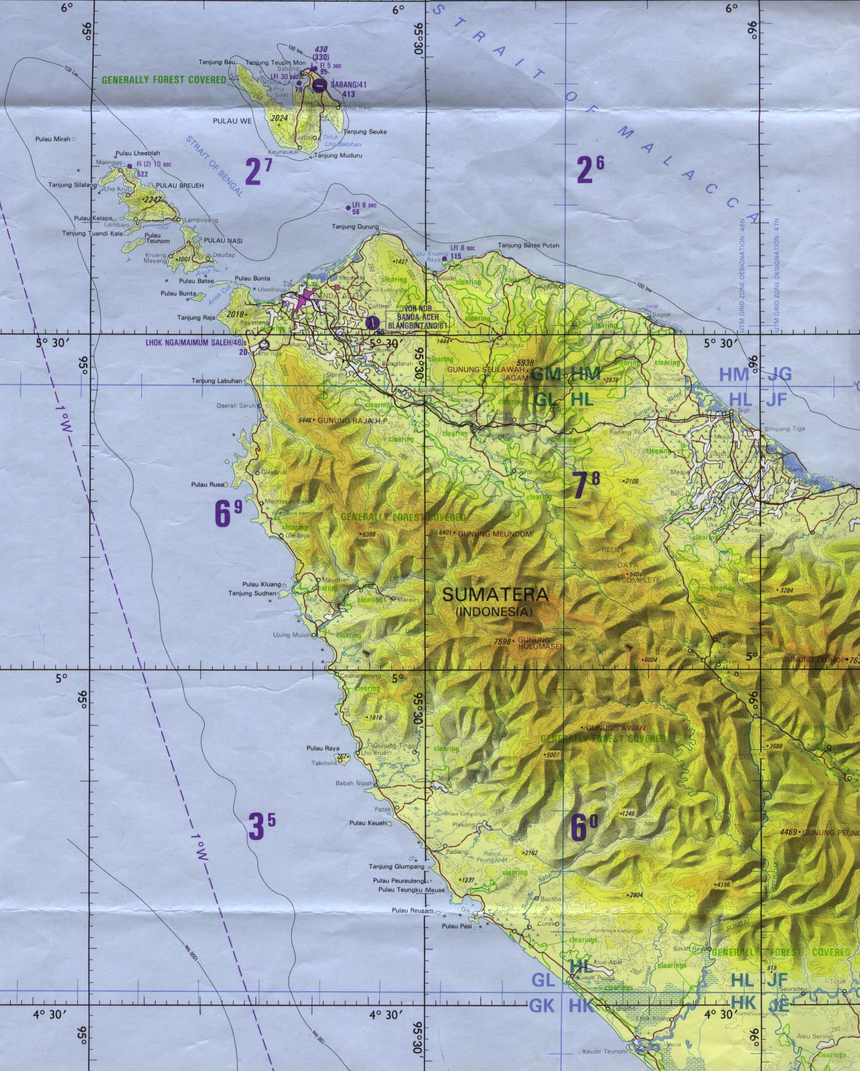
We set off for the short drive to Calang, which as you can see on
this map (also linked in the previous post), is situated on a promontory between two bays, with a scattering of small islands off the point and within the larger bay. This is our first glimpse of what was a bustling port town -- a small city, really -- when I stayed here in 1990. It had a defined "downtown" business district with shops of all kinds, banks, hotels. I recall having my coffee and "cakes" in the early morning at a coffee shop, and feeling entranced by the relaxed ambiance along the boardwalk -- and even more so by the exotic, sensual rhythms and soaring guitar riffs of
dangdut music. Calang was really a very pleasant little town then, but the tsunami left absolutely nothing behind.
This faded sign, located just on the edge of town, reads:
Rencana Lokasi Monumen Musibah
Gempa & Tsunami
Kabupaten Aceh Jaya
PEMDA Aceh Jaya
in other words
Planned Location for Disaster Monument
Earthquake and Tsunami
Aceh Jaya Regency
District Government, Aceh Jaya
I had been told earlier that Calang had a population of around 10,000, out of which only 200 - 300 survived the disaster. However later this same morning, someone told myself and Azir that around 75,000 had perished here. I'm not sure what to make of the discrepancy, except that local knowledge is generally more accurate -- and quite possibly the person was including all the small desas dotting the area around the city.
This was the only structure standing, also located on the southern approach to town. There did appear to be a few houses on higher ground, on the hill of the promontory that may have been pre-tsunami, but it was hard to tell. Basically the town centre now resembles an impromptu market area more than anything.
The road you see at right is the one passing through the town, and ending up on the beach of the small bay on the opposite side of the isthmus. I'm standing next to the beach, looking back toward Calang. Apparently the tsunami waves came at the town from both directions. You can see the same truck from Mon Mata parked by a house; I presumed they have family here too.
 |
|
Turning 90°, I catch a shot of Azirwan surveying the scene. The flimsy looking building behind him is a coffee warung, where I had an interesting chat with the young proprietor. He had lived in Calang for 10 years -- one of the few hundred people who survived. The reason for this was apparently something I've mentioned in earlier writings here, for he is a native of Simeulue Island -- which was the closest bit of land to the earthquake epicenter. The island was the first to be hit by the waves, and thus had the shortest amount of time between the quake and the deluge -- and yet only 6 people lost their lives there. The reason is that the island people have stories about a previous tsunami, and when they saw the sea suddenly go dry, they knew what it meant and immediately went for high ground. The young warung-keeper in Calang had been away from his house when the earthquake struck, and he went quickly home with some companions. He motioned to the area seen to Azirwan's left, that's where his house was. When the water in the bay suddenly disappeared, he called for his friends and family to get up the mountain, not too far away. In places where people did not understand the signs, many of them went down on the dry seabed to pick up fish.
 |
|
Turning another 90° toward the bay; these are some of the men from the big truck (who would later in the day become our saviours), with Azir and a few of the kids who travelled with us. The man in the centre is a Mon Mata survivor, quite possibly because he was up in the mountains to begin with -- because he was apparently, prior to the Aceh peace accord, the military chief for GAM in this district. I'll write more about the Aceh peace process in a later article. This beach was said to have been much closer to this nearby island, before the tsunami. I must add that this is an expression one hears a lot in Aceh -- before tsunami and after tsunami.
 |
|
Looking back toward Calang from the edge of the settlement; I wouldn't want to estimate current population offhand, but I was told that it is now close to what it was before tsunami. That would be just for the town itself, many of the hamlets surrounding it have not repopulated, or hold but a handful of tents and shacks. Of course now the population of Calang are mostly arrivals from elsewhere in Aceh. Behind the ruins you see the thin-walled temporary houses that most people in the town are living in. The previous scenes were located roughly at the left edge of this shot, at the foot of the hill in the background. Thirteen months ago, it was so depressing to write, "Calang simply doesn't exist any more," of a place that had long remained such a pleasant memory for me. But Calang exists again, as a testament to the resilience of these good people.
 |
|
Heading back out of town toward Mon Mata, a small desa holds on under tent cover. For one full year after the disaster, I was surprised to see that so many are still living this way. Remains of a mesjid are visible behind the tents.
There was a statement from the minister responsible for recovery programs which I heard a few days ago, saying that he expected that all people who are still living in tents would be into better living conditions by the middle of this year. At right is a new, permanent structure destined to be a school.
 |
|
We make it back to Mon Mata in late morning, but there will be no travelling until about 1:30. It's Friday, and people curtail driving until after noon prayers so as not to disturb the people walking along the narrow roads to the mesjid. So after eating with the folks at the big house, and some nap time, we set off with the previously sawmill-bearing truck behind us, also returning to Blangpidie. We had made it fine through this mudpit the previous night, but it looked scarier somehow in the daylight. The old man standing next to the truck on the right told us to go right through the middle, as he'd seen other cars make it there. Azirwan pondered and considered while I told him that whatever you do, get some momentum going and don't slow down. He decided to take the right side, and we didn't get very far.
 |
|
Azir and I are out of the car, considering our situation -- believe it or not, there are still about 10 women and kids in there! But soon enough, along come our saviours who thoughtfully have brought a rope along. They pass through the centre lane, back up to our Kijang, and pull us out almost before I can take a leak. Here they are leaving us their dust, a few more miles on.
Another quite nice looking housing project, somewhere between the road of pothole hell in the middle of the jungle, and the approaches to Meulaboh. Apart from the scenes in Calang and Mon Mata, the rest of these are taken on the fly out the car window. The previous day, passing this project, I noticed some of the writing on the windows of these yet unoccupied houses, and wanted to catch it on the way back as proof. Well I didn't catch it, so you'll just have to believe me: one was "I [heart] Aceh" and another read "I [heart] USA."
Getting back close to Meulaboh, approaching the mesjid where we stopped for lunch the previous day at Samatiga. The water in the centre is deeper than it looks by the man on the side, who is walking on high ground.
Just on the outskirts of Meulaboh lay the ruins of this prison. I was told that at the time of the tsunami, the prison held more than 300 inmates -- almost all of them members of GAM. All the prisoners and guards lost their lives here.
We dropped our passengers off in Blangpidie, and Azir and I went to find a noodle shop before taking the last stretch to Tapaktuan. We got back late, after telling everyone we'd be back the previous evening. We had tried phoning them from various points along the way, but cellular coverage was evidently not very good. I felt very bad because Ibu always worries when I'm out having adventures (as Mums always are!), especially spending the night away from home. I didn't want to cause her to feel
susah (troubled), but there was nothing we could do -- and she understood. She's a wonderful woman who loves me like her own son, and I love her back in equal measure. More about our family, and my time with them in Tapaktuan will be coming up shortly. Finally I apologise for the delay in getting this installment posted -- it was a holiday weekend here, and my services were required for being a chauffeur for a change, as opposed to being a passenger on cars, trucks and motorcycles these past 3 weeks.


")


 Our way of saying "thanks" in the Thai way. Here a nak muay Thai (kickboxer) offers respect and thanks for his teacher (wai khru) before a match. This is our local variation on the ubiquitous "hat tip" used in general blog culture.


