Politics, society, culture, freedom, democracy, Tibet, Thailand, Indonesia, Aceh, Southeast Asia, China, human rights, and any other subjects which are of interest to either Agam of Tapaktuan, or his unruly gecko.
The author may be contacted at agam [dot] tapak [at] gmail [dot] com Posting times are Bangkok time [GMT+7 = EDT+11].
The author may be contacted at agam [dot] tapak [at] gmail [dot] com Posting times are Bangkok time [GMT+7 = EDT+11].
SEARCH THE GECKO
TIBET INFO LINKS
 |
  |

BURMA FREEDOM VIDEO

E a r l i e r P o s t s
")
PROTEST AT RAGYA
Ragya, Machen County, Golog Amdo
March 21, 2009
March 21, 2009
UNDER ARREST
Lhasa region or city (unknown)
Date unknown
Date unknown
Search the web with 
M o n i t o r s


Quotation of the Day
Website content
provided by The Free Dictionary
W A I
 Our way of saying "thanks" in the Thai way. Here a nak muay Thai (kickboxer) offers respect and thanks for his teacher (wai khru) before a match. This is our local variation on the ubiquitous "hat tip" used in general blog culture.
A r c h i v e s

T i b e t
His Holiness the 14th Dalai Lama Tibetan Government-in-Exile
Tibet Information Network
Tibetan Committee for Human Rights and Democracy
International Campaign for Tibet
Canada-Tibet Committee
Phayul News
Australia Tibet Committee
Tibet Justice Center
Tibet Daily
Tibet Online Resource
Virtual Tibet Library
Dreams of Tibet
S o u r c e s
Memeorandum Snopes: Urban Legends
BBC | Monitoring
MEMRI
SITE Institute
A s i a P a c i f i c
Yahoo! News Asia The Jakarta Post
Paras Indonesia
Metro TV News Online
The Nation
Bangkok Post
Democratic Voice of Burma
Irrawaddy News
Mizzima News
BurmaNet News
Burma NewsLadder
Southeast Asia News
Sydney Morning Herald
The Australian


 Home
Home
Agam's Gecko

Saturday, January 28, 2006
WELCOME TO TAPAKTUAN, AND THE WAY TO CALANG
 |
| Tapaktuan, Kota Naga |
| I |
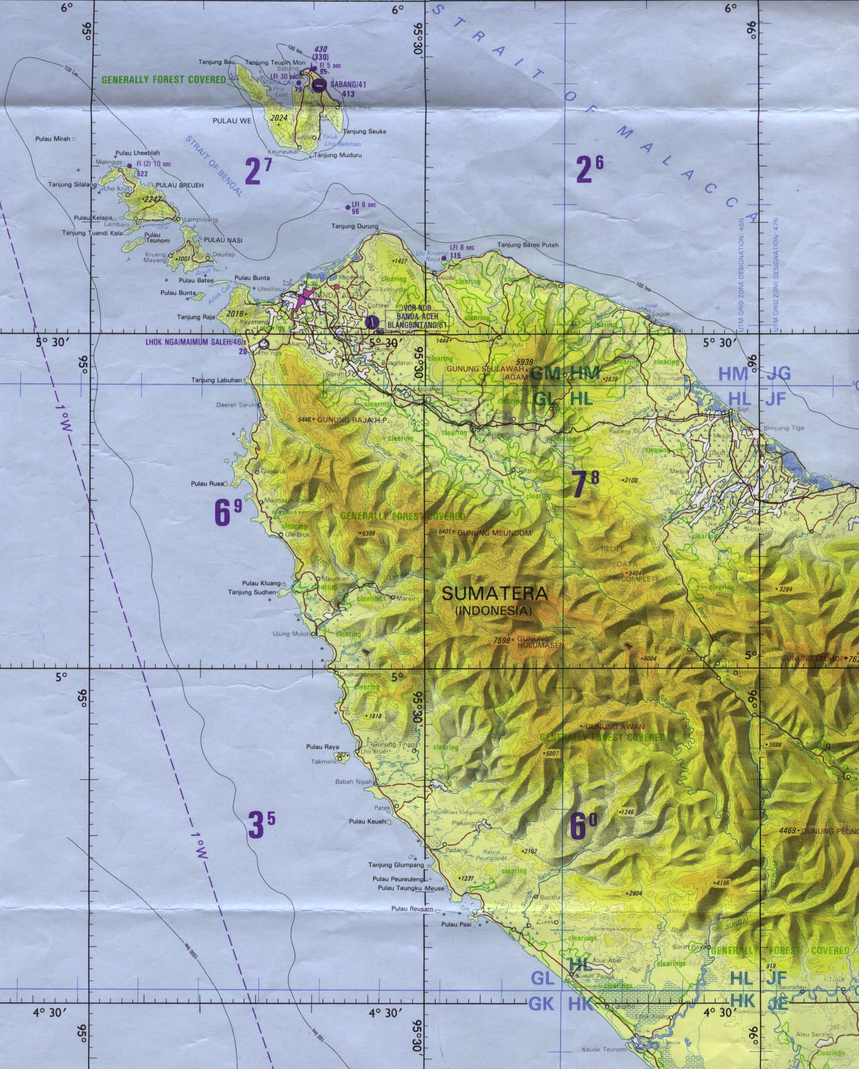
arrived on the afternoon of January 8, having left Medan the previous evening at 11pm. By pure coincidence (or not?), Bang (elder brother) Azly and Ibu (Mother) had flown from Jakarta into Medan just a few hours before me -- she had been in the capital since Azly had brought her and Ayah (Father) there a few weeks after the tsunami. Ayah had been ill at that time, was hospitalised in Medan, and sadly passed away soon after reaching Jakarta. The fact that we had independently booked flights on the same day was considered by everyone to be evidence of our "kontak batin," or inner contact. A family friend had driven the 10-12 hours from Tapaktuan to meet them in Medan, and so I travelled with them for Ibu's long awaited homecoming.
Some readers will know the story of my friend Uddin, the youngest of the brothers. We had known each other since 1990, and I made four trips back there until the last time I saw him in April 1998. By the following year, the conflict in Aceh had become hot -- the population was demonstrating in support of a referendum on Aceh's status, and the separatist movement GAM was launching attacks on both security forces and civilians. Following a massive show of support for a referendum in the capital Banda Aceh, and upon returning to Tapaktuan around October 16, 1999, Uddin was kidnapped and murdered. It is believed that demands had previously been made on him to join GAM, and he had refused. People in this area of South Aceh had been afraid to take any side during this period, for fear of repercussions either from GAM or the TNI, the Indonesian military. They preferred to stay out of either camp, and to support a peaceful and political path for a solution to the long running question of independence, autonomy or integration. The mass rally in Banda Aceh had been completely peaceful, and was estimated to have had around a million participants (the population of Aceh at the time was just over 4 million).
I believe that was the last full day of Uddin's life. He was taken to a GAM stronghold in nearby Kota Fajar, and killed in a most horrible manner. It would be another year and a half before I was able to return in April 2001, when I would first hear this story from Ibu's lips. Uddin's third son had been born just two months before he was taken.
 |
A few days after our arrival, another of our oldest friends (and Uddin's best pal) Azirwan came by in the evening to ask if I'd like to accompany him on a trip to Meulaboh and Calang ("Cha-lung"). He'd been hired to drive some people there, and I was welcome to join. Of course I would be ready at the crack of 7am! We would leave early and return the same evening -- or that was the plan. Normally it is about 3 1/2 hours to Meulaboh, and another hour and a half to Calang. Tapaktuan had been barely touched by the tsunami, and although I had already passed through one area which had been damaged -- at Bakongan, several hours south of here -- I was looking for an opportunity like this to see how the most badly hit areas further north were faring after a year.
 |
 |
Our little expedition -- who but for Azir and I, were all women and children -- stopped at around 3pm at a small mesjid, just beyond Meulaboh to have lunch. The men we talked to there told us we could drink the water in the mandi (in this case, a small outbuilding next to the mesjid for bathing and toilet facility). The mandi is a water reservoir inside the building. In Indonesia, you never drink any sort of tapwater without first boiling it. Here we were in the tsunami devastation zone, and there was clean tapwater to drink! Foreign aid -- as I recall in this case, it was Swedish -- had bored many water wells in these hamlets around Samatiga, to a depth of around 100 meters. The men told us that 13 such hamlets, or desas, had been completely wiped out by the tsunami waves. They pointed out a school next to the mesjid, which had been constructed by the French military.
 |
 |
 |
 |
 |
 |
[Read Part II of this journey here]
- posted by Agam @ 7:03 PM 1 comments
1 Comments:
Interesting trip. It reminded me of my childhood growing up on the west coast of Aceh. I was born in Tapaktuan and grew up in Tapaktuan and Banda Aceh. I used to travel from Tapaktuan to Calang to visit a relative who was a Wedana [county officer] there about 60 years ago.
I now live in Canada.
Usman Hamdani
uhamdani@bell.net
By  , at
03 January, 2010 00:32
, at
03 January, 2010 00:32
* * * * * * *
